Indian Monsoon
The monsoon has been disrupted in a big way this year, will this become the normal course?
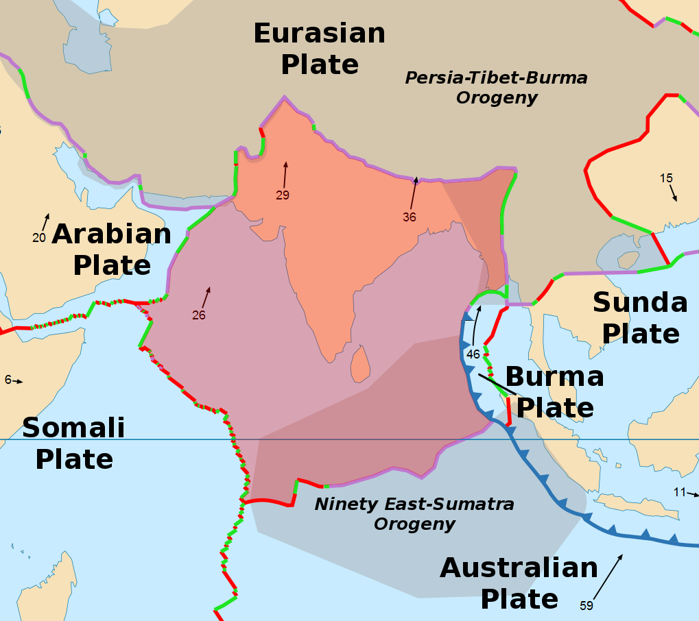
India was an island that separated from Pangea hundreds of millions of years ago. The separation created three significant landmasses, Australia, Madagascar and India. The separation of India and Madagascar created the Western Ghats in India and the same event gives Madagascar the central highlands and Tsaratanana Massifs.
As the Indian landmass moved north it crashed into the Eurasian plate. But before that happened, there was a waterbody called the Tethys Sea that existed all the way from what is modern-day Afghanistan to Myanmar. Hence, the Himalayas are one of the best places to find fossils of aquatic creatures from the era.
The meeting of the Eurasian and Indian plates led to the subduction of the Indian plate and the rise of the Eurasian plate. The Indian tectonic plate ploughed under the Eurasian plate. That gave us the Himalayas.
Source: Wikipedia
The birth of the Himalayas changed the Indian weather system completely.
But for the Himalayas, North India would have been dry and arid. The Gangetic plains would have been missing the river Ganga and would not have any agriculture on it.
The Monsoon
The Tropic of Cancer runs from Gujarat up to Mizoram dividing the country almost into two equal halves.
The Prevailing Winds on the planet change based on the latitude that you are present at. Between the Tropic of Cancer and the Equator, the winds move towards the East from the West also known as the Easterlies and above the Tropic of Cancer they from the West to the East, known as the Westerlies.
Source: Wikipedia
And here comes the peculiarity of the Indian landmass. India is surrounded by sea on three sides. During summers, the land heats up faster than the sea and this causes a low pressure to develop above the land since hot air is lighter and rises up. As the pressure drops, cooler air from the sea moves in to fill the void, bringing moisture and therefore rain. As a consequence even though the prevailing winds in India should move from East to West from land towards the sea, the reverse happens.
Source: Wettergefahren
This gives us the Arabian Sea branch of the monsoon which routinely paralyses Mumbai and ensures that Kerala and South Karnataka are heaven to live in. The sea breeze crosses the western ghat which is not high enough to entirely obstruct the clouds and delivers cool evening showers every day in Bangalore.
A similar thing happens in the Bay of Bengal and the sea breeze moves northwards and here is where the role of the mountains shielding the north comes into play. The moisture-laden air comes upon the Himalayas. The mountain chain runs all the way from Afghanistan to Arunachal Pradesh before turning towards the Bay of Bengal (you could refer to the diagram of the Indian plate above). It rises again briefly to give us the Andaman and Nicobar Islands.
The Bay of Bengal branch of the monsoon turns West thanks to the Himalayas and waters the entire length of the Gangetic plains.
This is how India gets its water.
So what changed this year?
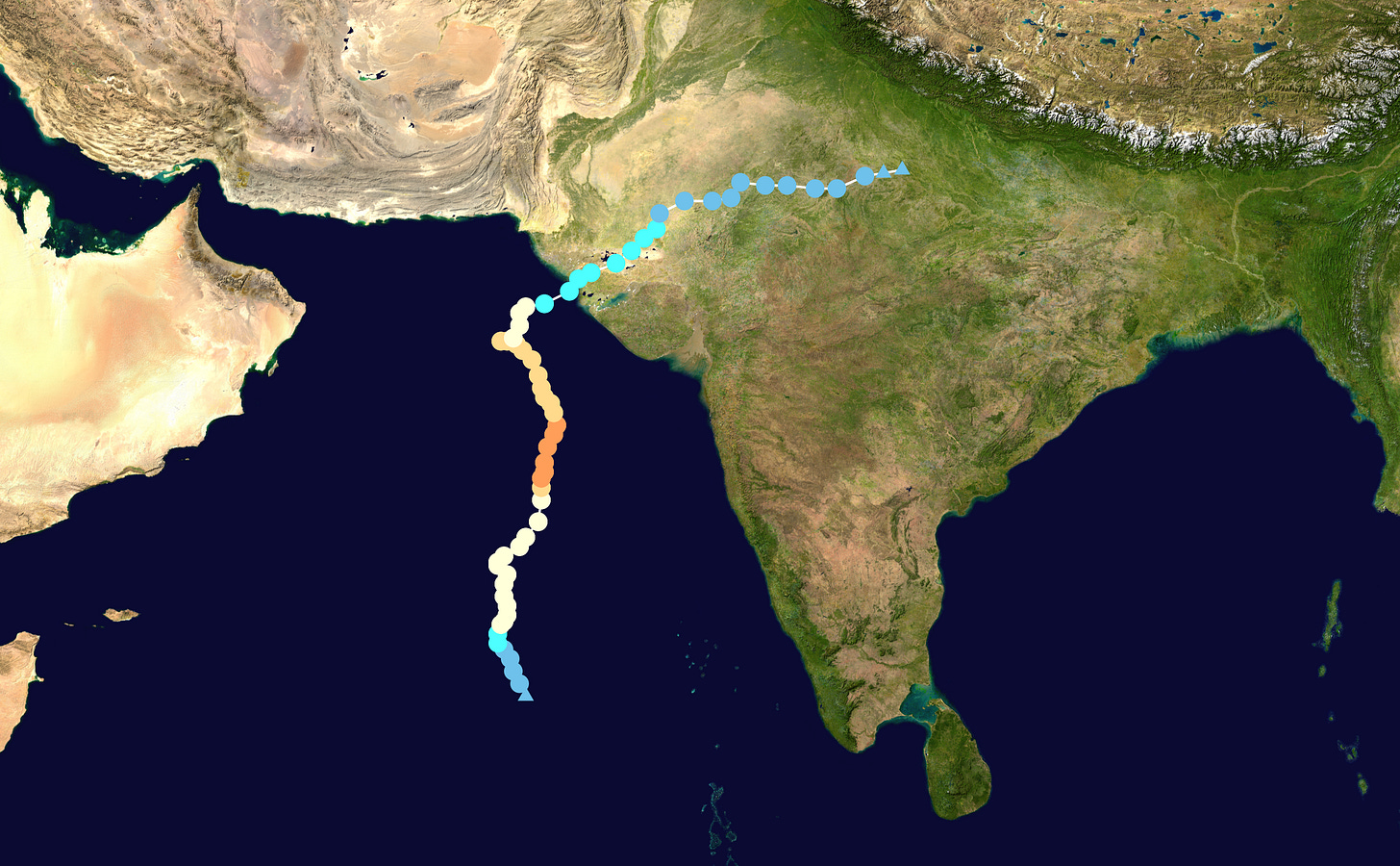
This year, cyclone Biparjoy sucked up the entire moisture from the Arabian Sea branch of the monsoon and took it all to Gujarat and Rajasthan. Consequently, Mumbai was not submerged in water! Instead, we had flooding in places that are not used to receiving much rainfall throughout the year.
Source: Wikipedia
This is the path of Biparjoy which formed on the 6th of June and dissipated on the 20th of June. As you can see, it went right up to Uttar Pradesh causing much precipitation all along the way.
Also the warmer weather this summer delivered a higher-than-usual volume of rain in the Bay of Bengal branch. The result was that Sikkim, Assam and Arunachal Pradesh have been flooded.
Nearly half a million people in northeast India have been affected by severe flooding after heavy rains battered the region, turning roads into rivers and submerging entire villages.
More than 495,000 people spread across 22 districts in the state of Assam have been impacted by floodwaters, its disaster management authority said in a statement Thursday.
About 14,000 people were evacuated to relief camps after torrential rainfall swept across the region, resulting in the river Beki, which flows through Assam, to overflow. At least one person has died, according to state authorities.
Source: CNN
The first instalments of rain arrived on the 22nd of June in the North-East. The rains have not abated since. Here is a report from 12th July.
The India Meteorological Department has issued a red alert for northeast India, Sikkim, and Bihar with the region expected to receive over 204.4 mm of rainfall.
The weather office also expects localised flooding, landslides and flash floods in these regions and has advised people to avoid areas prone to water logging and stay away from vulnerable structures.
Source: Mint
In the meantime, up North…
Having already received rains from Biparjoy, the additional rain from the monsoon caused the Yamuna to fill up and overflow in Delhi. This resulted in losses to the small shopkeepers who live and sell close to the Yamuna.
The Yamuna water level was recorded at 206.01 meters in Delhi on Monday at 11 pm, which is a level-up from the earlier gradual decrease in the water level of the Yamuna. Earlier on Monday morning, the water level of the Yamuna crossed 205.48 metres. This was slightly above the danger mark of 205.33 metres, even as the waterlogging persisted in several parts of the national capital.
Delhi is in the middle of battling one of its worst flood-like scenarios due to the recent heavy rain, with more than 25,000 people evacuated from inundated areas.
Source: Mint
The Taj Mahal is also located on the banks of the Yamuna and has a wooden foundation that has been crumbling because the Yamuna had stopped flooding.
The Yamuna river on ganga Basin's water level is on the decline, however the swollen river still continues to flow above danger mark at 205.46 metres, as noted by Central Water Commission (CWC). The Yamuna river's water level has risen so much that it touched the walls of Taj Mahal in Agra.
According to reports, this is the first time in forty five years that the Yamuna waters have breached embankments to reach the walls of Taj Mahal.
Source: Mint
Down South, several states were robbed of the monsoon by Biparjoy.
The crucial southwest monsoon had covered the entire country as of 2 July, six days ahead of schedule, but deficient rainfall in major food grain-producing regions is a cause of concern.
“Though the monsoon has covered the entire country and reduced the rainfall deficiency in eastern, central and southern parts of the country to some extent, the situation remains worrisome," said GP Sharma, president, Skymet.
Source: Mint
This is going to result in poor harvests later in the year. Of course, we will not have any discussion on climate and restrict ourselves to talking in sanitised terms such as inflation and the Consumer price index.
Historically, cyclones are known to form in the Bay of Bengal and the entire coast from Chennai all the way to Bangladesh is often at the receiving end of it. The cyclones that form in the Arabian Sea are often formed close to the Arabian Peninsula and have a particular liking for Oman. I looked up Wikipedia and could not find a single cyclone in history (at least since the 1800s) that has risen in the Arabian Sea and tracked towards India. This is a first.
And like that Climate changes!


